Cumbria Way "High Ridge" Route 2010

The announcement said doors were closing for my flight to Manchester, so I sprinted down the hallway with several other panicked passengers. Just made it.
My flight from San Francisco to Heathrow had been late, customs was short but the security line was long. I cut in front when I heard my flight called, then another line for photos, another for a paper check. I was lucky to make it onto the Manchester plane.
A quick exit at Manchester, 15 minute walk to the train station and a two hour ride to Ulverston where the Cumbria Way begins its journey north to Carlisle. Now that the rush was over, I could relax and enjoy the journey.
Selecting The Walk
I have walked many of the major paths in the UK, but never the Cumbria Way (CW). Perhaps I was never particularly interested because it wasn’t long enough (5 days) or seem challenging enough to warrant a trip from California. But then, I started looking at the route from a different perspective.
The Way passes through some terrific countryside from Ulverston to Carlisle (including the heart of the Lake District) albeit mostly at a lower altitude than the surrounding mountains. What if I extended the walk by taking extra days to walk the high ridges and mountains east and west of the path? In effect, making the walk a “high ridge” Cumbria Way. This was an exciting prospect, but would take a lot more planning than simply following a guidebook.


Standard Cumbria Way Route
Here Was My Rough Plan
- I could add climbing Coniston Old Man and Swirl How (west of the CW)
- I could add two days going from Elterwater to Patterdale via Fairfield and St Sunday
- and returning to Elterwater over Striding Edge (east of the CW).
- A fellow UK walker alerted me to the glorious Glaramara ridge on the way to
Rosthwaite in Borrowdale. This sounded too inviting to pass up (west of the CW). - There is the Dale Head ridge walk from Borrowdale to Buttermere, then I could take
an extra day to climb Haystacks and possible High Stile (west of the CW). - There is the incredible Whiteless Pike/Causey Pike ridge walk from Buttermere
that has been beckoning to me for a couple of years (west of the CW). - I would like to spend an extra day at Keswick to climb Blencathra via Hall’s Fell
(northeast of the CW).
Based on these deviations, the most I’ll see of the Cumbria Way will be the first two days out of Ulverston and the last two days from Keswick to Carlisle. Because I’ll be deviating most days, route descriptions are written in quite a bit of detail so that other walkers can easily reproduce this walk if they choose.
Preparation And Ulverston Arrival
As usual, I pre-booked all my accommodations and purchased my train tickets on-line six weeks in advance (for lowest fares). I’ll be walking with 15 pounds in my Osprey pack, a Marmot jacket, Lowa boots and Komperdell carbon ultra-lite poles. I’ll be using OS maps along with the Cumbria Way guidebook by John Trevelyan.
When I arrived in Ulverston, I found my B&B locked tight so I toured the indoor market, shook hands with the Laurel and Hardy statues (Stan Laurel is the hometown celebrity), saw some interesting old buildings, picked up £200 at the bank ATM and purchased a box of Compeed to care for any future blisters on my feet.
I was hungry so I popped into the King’s Inn. I had a pork dinner for only £3.95. The Tetley’s XB (a dark ale) wasn’t well kept, so I wish I had chosen the more local Robinson’s. The owner was very friendly and gabby. He was telling me how this part of Yorkshire was the best, south is too urban, north is too skint, east is too ethnic and west is too close to Iceland (?). Also, he bragged about making the best Yorkshire pudding (it was terrible). At least he was entertaining.
Finally, I went back to the B&B and saw the kid coming home from school. He was surprised the door was locked so went next door for the key and let me in. Soon the daughter came home all apologetic; her mother was out of town so she is running the place. I took a shower and crashed about 6:30 pm. I didn’t wake until 6:30 the next morning, a solid twelve hours sleep.
Day 1 …. May 8 …. Ulverston To Coniston …. 17 miles

A side street leads to The Gill, a car park, where the Cumbria Way begins along a beck.
Up onto the hills it’s easy walking, a little harder to negotiate the farms. St. John’s Church is a delight built of dry laid field rock and has a circular nave on the south side. Here was my first open view of the lakeland mountains to the north where I’m heading.


It’s very nice and pleasant open country, passing over a clapper bridge, by a ruined stone farmhouse and around Beacon Tarn, then along a beck to Coniston Lake. The lake side path carried me to Coniston, a picture perfect lakeland village. Coniston Bluebird Brewery, one of my favorites, was hiding behind the Black Bull pub (on the left). Holly How YHA, my bed for the night, was one km north of town.

I arrived at 16:30 and found the hostel packed with cyclists, only one other walker. The next day was an annual Lake District race, 112 miles including Kirkstone Pass, with 1200 cyclists. Average time is 7 1/2 to 8 hours. Spandex is everywhere.
Dinner was at the Black Bull. They had four different Bluebird ales. The barman poured
me a sample of each, I chose the Blacksmith. The Old Man Ale was a close second. I had an excellent haddock with salad in place of potatoes. Back to the hostel before dark, cyclists were already sacking out. Tired from my first day, I was asleep by 9 pm.
Day 2 May 9 Coniston/Old Man To Elterwater 18 miles
Most cyclists were gone when I arose at 6:30. Not many eating breakfast; very good coffee and food for a hostel. It was greatly appreciated. I left by 8:15 and was soon passing in back of Sun Inn. Before walking to Elterwater today, my plan was to loop over Swirl Hause, then to Old Man Coniston by way of Swirl How, Great How Crag and Brim Fell. The weather was fantastic today, blue skies with some white fluffs.

After passing Coppermines YHA, the gravel road ends and I could either backtrack to a higher path or cross the beck on a bridge and follow waterfalls up to Levers Water (a reservoir). I chose the waterfall path as it looked a little more exciting. The waterfalls were spectacular and close enough to get splashed.

Skirting Lever’s Water, I eventually met the other path and came to Swirl Hause on the ridge loop. This is where, five years ago, in ferociously windy and freezing weather, I turned back down to Coniston after climbing Wetherlam.
This morning, in fine weather, a runner came by off Wetherlam, then another came by off the fells. As I started up to Swirl How, I met a walker coming down. He had been to the Old Man, walking for three hours, I’ve been walking for two hours.

It was a rocky climb up to the summit of Swirl How. On top, there were great views in all directions. I was on a true ridge that stretches all the way to Old Man Coniston, seemingly on top of the world.
After reaching Swirl How, I continued along the ridge past Great How Crag and Brim Fell to a path which deviated over to Dow Crag. I met a couple coming over from Dow Crag who volunteered to take my photo with Dow Crag in the background. Then I continued on to Old Man Coniston.


I reached the Old Man Coniston summit, 2631 feet, at noon and ate a piece of homemade chocolate brownie from the hostel before descending. By then, this poor mountain top was covered with exhausted humans coming straight up from Coniston. The trail leaped straight down and so did I.


Many people were still coming up, struggling, looking unprepared for such a difficult climb. I passed through dramatic slate quarries with open mines and huge leavings on the hillside. I was in Coniston by 13:30, and stopped at a table outside a pub to eat a banana and energy bar to prepare for the walk to Elterwater.
Back on the Cumbria Way, I had to navigate a mass of people at the cycle race finish line to access Shepherd’s Bridge and the countryside. At Tarn How Cottage, I made a wrong turn, or rather, I went straight through a gate with a yellow arrow instead of turning left to Tarn How. I soon realized my mistake and, audaciously consulting my map and compass, found another path to Tarn How.

After the lovely walk around the tarn, I made my way to Skelwith Bridge and then Elterwater village along the Cumbria Way path past Elter Water. My objective for the night was High Close YHA, up on top of the bank (ridge) on the way to Grasmere. I looked longingly at tourists eating at the Brittannia Inn as I passed by, but knew I would have dinner at the hostel.
It was a long steep climb to the hostel and I was extremely tired. Halfway up, my legs gave out. A car came along and I flagged him down. He was going to Grasmere and gave me a ride to the hostel. Not my finest hour, but I was very appreciative of his help. In retrospect, I should have broken this day into two and spent a little more time in Coniston, perhaps adding Wetherlam to the walk. The second day, I could have spent some extra time in Little Langdale.
I arrived at 18:00, sorted out my room and popped into the dining hall where others were already eating. They were a walking group from Liverpool, out for four days. The warden set my beer down at an adjacent table but they all called me over to join them. They were a jolly group, all in their 50’s, 60’s and 70’s, with several bottles of wine to lighten the day’s load and we had a nice evening together. My tired legs were forgotten but I did need a Compeed for a blister on the sole of my left foot before going to bed.

Oh, by the way, as you can tell from the photo, the hostel architecture was grand, a late Victorian mansion with a sweeping porch, beautifully wood paneled rooms and huge fireplaces. Worth the visit!
Day 3 … May 10 … Elterwater To Patterdale ... 15 miles
After a very good breakfast, I left by 8:40. The walking group were going up Silver How in the Langdales, but I’m going east to Patterdale on a two day deviation from the Cumbria Way. It’s a short walk over the bank to the Loughrigg Terrace path which overlooks Grasmere Water on it’s way to Rydal, the famous home of William Wordsworth.


Just past Wordsworth's house is the start of the climb up onto the Fairfield Horseshoe, a spectacular ridge, first running north, then circling around south to drop down to Ambleside. I will leave the horseshoe at Fairfield summit, halfway around the horseshoe, to continue northeast to Patterdale. First, I ascended a steep path to Nab Scar, then up to Heron Pike at 2000 feet.


The overall weather today was gray and cold, but a little sun was trying to peek through blue patches in the sky. The views back toward Grasmere and Ambleside were spectacular. I played leapfrog with a friendly couple from Hampshire as we made the long climb to Great Rigg Man at 2513 ft. They took my photo pointing towards Fairfield Summit. The ridges at the top of the horseshoe and around the south side were very dramatic.

I was starting to see snow on the ground, it was getting colder, no more sun, a dark sky. At Fairfield summit, 2663 ft., I was making deep footprints in the snow. A few walkers are doing the full horseshoe down to Ambleside, some are huddled against the wind in the stone shelter. The next photo shows where I have walked, with Grasmere in the distance. The second looks forward around the horseshoe.


I had hoped to walk along the St. Sunday ridge, but the sharp, obscured descent to Cofa Pike and Deepdale Hause looked daunting with this bad weather. Not today. Never having been here, I didn’t want to chance the unknown and unseen.

St. Sunday Ridge Route Not Taken
So I put my backup plan into action. I walked, through snow, over to Hart Crag where I found the path to Hartsop Above How, the ridge descending to Bridge End and Patterdale. This path was recommended to me by an English walking friend.

Lucky for me, the path seemed easier and certainly clearer than the descent to St. Sunday. Nevertheless, it was a steep, rocky drop down to the ridge, then a quite rough up and down along the ridge, harder than I expected. At least the weather was calmer as I dropped altitude.

Finally, I saw lambs nursing on the fells and my B&B, Noren Bank Farm, far below along the road. It has been a very satisfying, dramatic walk with stunning mountain views the whole way.

My room was in a humble farmhouse but very comfortable. I arrived at 16:10, plenty of time for tea and coffee, a hot shower and relaxation before dinner. It was only 1/2 mile to the White Lion Inn, not very busy on a Monday after the weekend. I ordered veggie lasagna with a large salad and a Bass Special Ale…..all was good. Customers started arriving about 18:30 and I left an hour later. After journal writing, it was early to bed.
Day 4 ... May 11... Patterdale To Elterwater Via Striding Edge ...15 miles
A beautiful, frosty morning greeted me through the upstairs window. Breakfast was at a sensible 8:00 and I was off by 8:35 with a banana and a pear for my lunch.


I gained the fells behind the post office, overlooking Ullswater, as if to climb St. Sunday, but cut down across the bridge at Grisedale Beck and started the long climb to Grisedale Brow. I already started feeling the adrenaline in anticipation of straddling Striding Edge.


Eight other walkers were on the trail; a couple passed me and I passed six others. Most of the hard climbing is done when the Brow is reached at 2000 feet; then there is another 500 ft climb to Striding Edge.


Across the valley, St. Sunday was very prominent through a light haze and I could see the descent from Fairfield. I’m glad I didn’t take it yesterday, doesn’t look nice. I saw walkers starting to make their way across the Edge. It’s been two hours to come this far and will take another hour across.

The Edge was surprising - extremely rocky, many ups and downs like hills and gullies. There are places you can bypass the top edge. I walked the top in most places (1 yard wide) but took advantage of the bypasses when I didn’t feel comfortable. The young couple in front of me walked across every high section. At one place, there is a drop down a chute where you have to wedge yourself and lower your body, maybe 20 feet, pressing against the side with your arms. The couple was having a hard time, so I went to the other side of the Edge and found a different way. Finally, there is a rock climb straight up onto Helvellyn. Oh, I packed my poles away because I constantly needed my hands to rock scramble.

This route wasn’t scary so much as very hard. On each side of the Edge, the slope is almost vertical all the way down so there was vertigo to contend with. Finally, there is a rock climb straight up onto Helvellyn. I don’t seem to be as scared of heights as when I was younger - in my twenties, I don’t think I could have done this. I think I conquered much of my fear of heights when I was climbing the Himalayas in Nepal.
Elevation on Helvellyn is over 3000 ft with quite a bit of snow. It’s hard to explain to people in California that 3000 ft here is like 12,000 ft in the Sierra Nevada Mountains because, I think, of the difference in latitude.
I talked to four guys from Poland who spoke little English. I left them with “muchas gracias, adios”, they reply “por favor”. I surprised them and they surprised me in return.
A long ridge led to Dollywagon Pike, then down, down, down to Grisdale Tarn at 1768 ft.
I rested next to the Tarn, an idyllic place for lunch. Lunch was a banana, the last half of a rocky road bar, a stick of cheese I unexpectedly found in my pack and lots of water.


It was 13:00. I crossed over Grisdale Pass and started the 1 1/2 hour descent down Tongue Gill to Grasmere…..easy going. At the Co-op in Grasmere, I treated myself to an ice cream bar, then circled the far side of the lake to find the path to Elterwater. I crossed the ridge and had a look back over Grasmere Water, passed by High Close and on down to Elterwater YHA in the village; arrived at 16:30.

At the hostel, My dorm mate is Jeff, age 59, an avid climber. He is slowing down, so has hired a guide to help him with some difficult technical climbs, climbs he has wanted to do all his life. Go Jeff! As I was fascinated with what he is doing, he is fascinated with what I am doing.
Day 5 May 12 Elterwater To Rosthwaite Via Glaramara 15 miles
A small group of us four elderly gentlemen were down early for breakfast at 7:30. We ordered and got served, no squabble. A class act for the breakfast crew. Jeff and I both left about 8:30, he was anxious get onto the Langdales and climb Gimmer Crag. I think it was a bucket list kind of thing for him. I headed off along the Cumbria Way above the beck and soon passed by Wainwright’s Inn. I’ll have to stop there sometime and find out if the name has historical significance.

I came to the New Dungeon Gyll Hotel after 1 1/2 hours. This is the normal stop on the Cumbria Way, so I fell in with a few other walkers starting out late. After passing the Old Dungeon Gyll Hotel, it’s a fairly level path skirting the fells high above Mickleden Beck curving around from west to north to the foot of Stakes Pass. Here, most walkers will continue on the CW over Stakes Pass while I and several others turned left (west) to ascend Rosset Gill to Rosset Pass and on to Angle Tarn. The sign painted on a boulder actually says Esk Hause which is beyond the Tarn.

Ascent to the pass and tarn is from 500 ft to about 2000 ft. Part way up there is an option to go up the gully on right side of the path but it looked exceptionally steep, rocky and slow; best stick to the switchback path. I played leapfrog with two younger walkers but they plunged ahead after reaching Rosset Pass. There was a 200 ft descent to Angle Tarn which is quite beautiful, framed by the mountain.

As impressed as I was by Angle Tarn, I was positively enchanted by a small unnamed tarn that I dubbed “Little Tot Tarn.” It was certainly worthy of recognition.

An escape path led back down to the CW on the other side of Stakes Pass. Otherwise, my path kept leading west up to a junction at 2370 ft. Straight ahead would lead me to Eskdale, left to Esk Hause and right, my route north, to Allan Crags at 2512 ft and the Glaramara ridge. Views here were spectacular if a bit hazy and cloudy which unfortunately affected photographic clarity.
I turned right and immediately met a local couple who just came across Glaramara. We talked awhile and he pointed out all the peaks around us. To the south, Bow Fell and Esk Pike. Turning west, we could see Scafell Pike, Great End, Great Gable, Green Gable, and further west, Pillar. It was quite a magnificent lineup. The weather was not bad, but not good either. Lot’s of gray clouds which the eyes can penetrate and adjust to, but the camera cannot do justice as you can see.

I climbed to the top of Allan Crags and discovered a couple having lunch behind the summit rocks, hiding from the cold wind. I sat with them and ate a pear. They were on vacation from the south of England and came to the lake District often for walking.
It was a very rocky path with several summits on the way to Glaramara. The path was followable but could be indistinct among the rocks, especially over the abrupt wall in front of me. I finally reached the summit of Glaramara at 2560 ft and had a fabulous view to the east, the Langdales and a whole lineup further away.


I tried to spot Jeff in his distinctive orange jacket, but could not tell which was Gimmer Crag. To the north, I could see the long valley of Borrowdale stretching all the way to Keswick against a tumultuous sky. Seeing no other walkers at Glaramara Summit, I couldn't resist a selfie to honor this occasion.

After the summit, there is a precipitous drop, part of it is almost like a chute (think Striding Ridge), rock scrambling and hanging by fingers. Then, on a flat part of the ridge, as I passed two exquisite tarns, a dark storm swooped in from the north throwing some sleet at me but mostly passing just east, a glamorous show of nature.


A gradual descent into lovely Borrowdale followed, very rocky and hard on my feet. At Thorneythwaite Farm, I chatted with an older couple out for a little walk on the fells. Reaching the road, it’s only a mile to Rosthwaite where my hotel awaits. I met a South African who had just said goodbye to his girlfriend who boarded a bus to go back home. He works at the Scafell Hotel, next to the Royal Oak (my hotel). He said the Riverview Bar in the Scafell is excellent. I’ll have to remember that.
The Royal Oak is an old fashioned hotel with a set dinner at a set time which is mandatory for all guests. Tea, coffee and scones (complimentary to guests) are served from 3 to 5 pm, excellent and classy. I arrived at 4:45, just in time to dump my pack and partake of the goodies. I had a nice, large en suite room with a big bed. This was the most expensive lodging of the walk, but was well worth it. No other rooms were to be found on this night, even the hostel was full.
After cleaning up, I was down to the bar by 6:30 to spend time till dinner at 7:00. Theakson’s was the only ale on tap, very good, but I wondered what the bar in Scafell’s was like. Dinner was a mushroom and cauliflower soup, pork medallions, potatoes, bread and vegetables; lemon cheesecake and ice cream for dessert. For those who didn’t want sweets, there was a cheese table with crackers. Then everyone retired to the drawing room for coffee or tea and chocolate mint leaves, all very proper.
I made friends with four recent retirees from Manchester, doing the coast to coast walk, bags carried by Sherpa, and having a grand old time. After exchanging stories, I went up to my room for journal writing and reading. I was ready for a good night’s sleep.
Day 6 May 13 Rosthwaite To Buttermere Via Dale Head 15 miles
Breakfast was at 8:30, so I did not get off till 9:15. Goodbyes to the four C2Cer’s. They went south and I followed the Cumbria Way north across fields, woods and an exquisite stone bridge to Grange.

The CW path is on the valley floor but, eventually, I will climb up onto the ridge to walk a curving path past Dale Head to Buttermere, first going back south, then west. It was another beautiful day for walking.
There are two ways to gain the ridge, one at High Spy, the other further north up to Maiden Moor. I talked to a couple who said the first path was in terrible condition and highly recommended the second. Also, I wasn’t sure exactly where the High Spy path started. I later found out it left the CW path near the campground before Hollows Farm.
I detoured into Grange to look at the famous double arched bridge over the River Derwent, but trees hid the possibility of any decent photo.


North of Grange, I turned west to make the long ascent to the ridge at Maiden Moor. I will follow this ridge all the way to Buttermere.

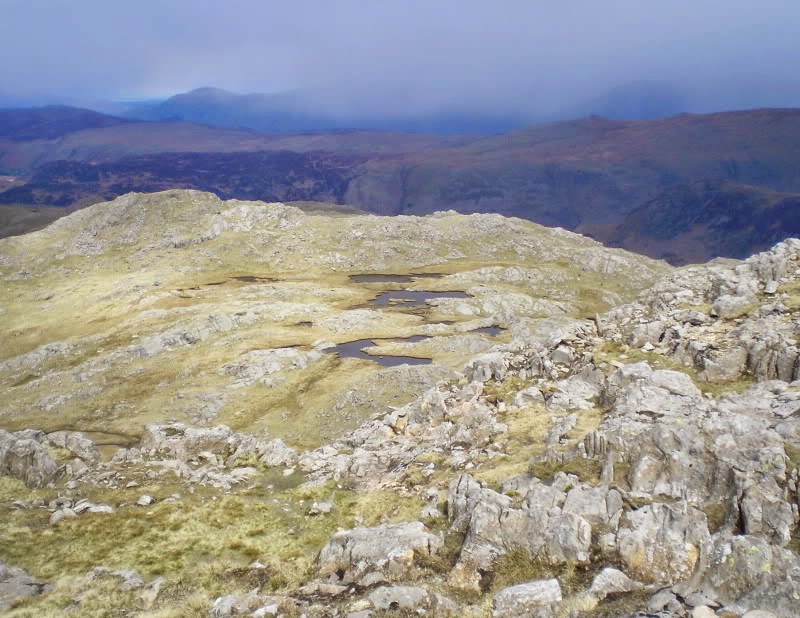
At the top of the ridge, a path to Cat Bells heads north; I turned south. Climbing higher and higher, I passed Maiden Moor Summit, reached the summit cairn at High Spy (in photo) , then followed the long ridge further south.
It was a long descent to lovely Dale Head Tarn. I named it Duck Tarn because of the wildlife on the water. I crossed a wild looking Newlands Beck, then began the exceptionally steep climb up Dale Head to the summit cairn (in photo) where I could look north along the long ridge where I had just walked.


As I continued along the Dale Head ridge westward, Dale head itself loomed behind me and views all around were incredible. To the west I could see Hindscarth and behind it Robinson, both high ridges jutting north off the Dale Head ridge which runs west. South, I could vaguely see the peaks and ridges from yesterday, hiding among the clouds. Looking closer, I could see Fleetwith Pike and Haystacks just south of Buttermere (lake) but, sadly, these southern vistas were not photographable.

The weather became windy and cold, lots of clouds blowing by with intermittent sun, made it hard to get good photos. It was so cold I stopped to put on my earflap cap and gloves. Further along the ridge, a sleet storm lasted about ten minutes when an extremely large, dark cloud blew north. I detoured up to the summits of Hindscarf and Robinson, two little northward excursions along their ridges.

Back to the business at hand, my main path continued on to Buttermere village at the western end of Buttermere (lake), but my B&B for the night was closer to the eastern end so I started looking for the direct path down to it. This proved difficult to find but I teamed up with two fellows who were also trying to find it. Success!


At first, it was an easy path but then dropped off the cliff straight down. I had to use my hands to lower myself in places. It was like this for about 1000 feet. I was very thankful to find the path leveling out and entering a picturesque bank of trees along a beck tumbling down from a ravine.
Soon I reached the Buttermere road and crossed over to find Dalegarth B&B on the lake. It was 4:45. Jeremy showed me to my room, not en suite but it was quite large with twin beds and had a wash basin. I cleaned up, sorted my laundry for Kelly, then was off on the lakeshore path to the pubs at Buttermere village. I reserved two nights at Dalegarth so I would have a day to visit the high country around the lake before walking to Keswick. There are two pubs in Buttermere, so I planned to visit one each evening.
In the evening, I stopped at the Fish Hotel and found Snek Lifter ale from Jennings Brewery. I matched it with a Prawn Thai Curry and rice. Both were excellent but what does Snek Lifter mean? The pub was busy and very convivial. I decided to scout the other pub, the Bridge Hotel, and found Black Sheep ales and two ales from Hawkshead Brewery. Also on tap was Old Peculiar (an iconic black ale), so I had a half pint for dessert, then walked back to the B&B. I listened to music in the lounge, looked at Trail magazines and wrote in my journal; a nice finale to the day.
Day 7 May 14 A Buttermere Walk On High … 12 miles
Rain moved in overnight and stayed wet off and on in the morning, so I put my Duck’s Back cover on my pack and planned to leave it there. Jeremy and Kelly served a wonderful breakfast, two of everything, an overwhelming amount of food; I guess I just don’t eat as much as some folks. My plan for the day was to go up the Scarth Gap path to Haystacks, then see if I wanted to go higher to High Stile and Red Pike. I talked to three men who came from Braithwaite yesterday. Today they are going to the Eskdale YHA near Boots by first climbing over the pass at Scarth Gap.
They left before me, but I caught up to them at the east end of Buttermere Water. We walked together awhile, then I left them behind as we started climbing with a wonderful view back to Buttermere Water.. There was a light rain and the clouds got heavier as I approached Scarth Gap. I turned left (east) to begin the climb up Haystacks.


I met a couple bringing yellow daffodils to throw where A. Wainwright’s wife scattered his ashes in 1992. They do this every year and seem to know the exact spot of the scattering (on Imnominate Tarn) which has supposedly been kept secret.
NOTE! A. Wainwright is the most famous fell walker in England and has written numerous books on the subject. The couple led me up the steep rock face with lots of scrambling. This was not a hard climb, but the rain and slippery rocks makes one very cautious.


Several people were on the summit of Haystacks taking photos of the iron pike marking the spot at 1900 ft. An exquisite small tarn was just below. The couple with the daffodils moved on, continuing their spiritual journey. With the cloudy, rainy weather, it was hard to see much, but glimpses through the mist had an ethereal quality.
I started back down and looked to the west across Scarth Gap, toward my potential ridge walk for the afternoon. At a higher altitude, the mountain was blanketed in dark clouds so I said “enough is enough” and decided to go back to Buttermere for a half rest day and a pint at the Fish. At Scarth Gap, I met a couple who wanted to know if where I came from was the way to Borrowdale. I assured them it was and wished them good luck. Then I scampered as fast as I could back to Buttermere with no regrets.

I stopped at the Fish Hotel for a snack and a pint of Thirst of May, a dark, porter-like ale known as “mild”, from Keswick Brewery. It hit the spot on this rainy, gloomy day. On the way back to the B&B, I passed through Wilkensyke Farm where their ice cream van is located. The van was open, selling farm made ice cream from their own cows. It was superb.

I collected my clean laundry from Dalegarth’s drying room, took a shower and then had a cup of coffee while reading; basically, goofing off and relaxing. Later, as I walked back to the village, the weather was clearing and sun was out with only passing clouds.
For dinner, I tried the Bridge Hotel for their roasted Lakeland trout matched with Buttermere Bitters from Hawkshead. I was told the trout actually came from Buttermere. It is uniquely different from American trout, having a pink cast to the meat and tasting somewhat like salmon but lighter. Back at Dalegarth, I talked with a London couple in the lounge who are drinking a bottle of California Shiraz. Oddly enough, he works for Oracle, a California IT company.
Oh, I found out what Snek Lifter means; part of an old fashion door latch that lifts the catch. Now I can sleep at night.
Day 8 May 15 Buttermere To Keswick Via Causey Pike 15 miles
I had a light breakfast (compared to yesterday), even yoghurt, no toast but a croissant.
I sat with two blokes who came in yesterday. They walked across Dale Head like I did and came down the same vertical path from Robinson to Dalegarth. “Never again.”
Goodbye to Jeremy and Kelly, nice people, a good B&B. They wouldn’t even take money for washing my laundry. I left at 8:15, heading for the path up Whiteless Pike.

I reached the path gate at 8:35, an iron gate across the road from the Bridge Hotel. A National Trust officer I met the day before told me how to find it. The sign on the gate said Gyll Wood. The path followed the gill (stream) until steps pulled me out of the ravine onto the fells.
I overtook two older men slowly trudging uphill and recognized them from the Fish Hotel bar. They were there each of the three times I was there, holding down the end of the bar. They have come to the Fish annually for 18 years. Wow!! The clearing weather allowed a nice view down to the village of Buttermere, the west end of Buttermere Water and the ridge that, yesterday, I decided to pass on.

The NT officer said it was a steep climb up to the Pike, and yes it is. The ridges ahead, up so high, looked daunting and I was beginning to wonder what I was doing there. Even though the weather had mostly cleared, the ridges looked dark and brooding, Whiteless Pike at 2160 ft, Wandope at 2533 ft, and Sail at 2750 ft. Further along the ridge, Scar Crag at 2200 ft and Causey Pike at 2000 ft. But this is what I came for; one of the longest, continuously spectacular ridges available for walking.

I again looked back over Buttermere and clearly saw the ridge that was covered in cloud yesterday. It looks like a marvelous walk. I will definitely schedule it for another year. In quick succession, I met three lone walkers going to Buttermere. Two of them said “It’s a long walk to Keswick.” Thanks a lot, you are a big help! Actually, it wasn’t THAT long. After a couple of false summits, I reached the summit of Whiteless Pike; it felt good to get there; now it all seemed possible.

On the climb to Wandope I saw a group of walkers going up Grasmoor to the west, framed in a line against the sky. Others were wandering around on the summit of Wandope, they probably came up from Braithwaite.

At a junction of paths, I turned east to climb up onto Sail, the highest point of the day. From here, there was a series of descents and ascents, gradually losing altitude. I met a walker at Sail summit and he took my photo with the summit marker.


I spoke with several others along the ridge. One fellow was running with his dog, said he was going to Canada and San Francisco in a fortnight. He ran up to Causey Pike summit and returned. As he passed, I gave him my card and said to call and visit. At Causey Pike summit, my walk from two days ago was visible in all it’s grandeur, from Maiden Moor to Dale Head and around to Robinson.


After Causey Pike, it was a steep drop off with serious rock scrambling. The time was about 13:30, so I stopped for a snack, then followed the path over Rowling End to the road.

I crossed the road to Stair, then walked up past Swinside which has a B&B and a pub with rooms to let; it looked like a nice place to stop for the night. These are back lanes with little traffic, so I continued on the road to Portinscale where I met the Cumbria Way coming up from Borrowdale. A walk across a suspension bridge and a field into Keswick put me into town center where a huge banner announced the annual Keswick Jazz Festival. A traveling market was set up on the pedestrian street under the festival banner and in the shadow of town hall. I was tempted by the map stall and several Asian food stalls, but no, it’s only 3/4 mile to Craglands B&B.

Pauline greeted me with coffee and cookies as usual for B&Bs. For dinner and good ale selection, she recommended Banks Tavern and the George Hotel. She said this was the last two days of the jazz festival; bands are set up in various venues all over town, you just have to look around. I cleaned myself up and went out for the evening.
Banks Tavern was completely full so I went to the George, it was full also. I heard music so followed the sound, down the street to a coffee bistro where a band was set up in the front window. It was packed but I squeezed in and got a pint of Thirst of May. The band had a piano, trumpet and clarinet with an older female singer. They were playing thirties style jazz. The piano man played 12 bar boogie-woogie in 8 bar style….sounded good to me. The singer had a deep voice, displayed a great style and sang nice standards. I had a little chat with them. They were all English and had been together a long time.
Finally, I went back to Banks and found a table squeezed between some local guys. I ordered chicken curry and a pint of Marston’s Pedigree. There was a lot of jovial banter with the guys. One was drunk and refused to believe I was an American; his friends were trying to take him home. Everyone was having a good time. Jazz was forgotten.
Day 9 …. May 16 …. Keswick To Keswick Via Blencathra
I decided to take the late breakfast at 9 am so as to sleep in and give the weather time to clear up after an overnight rain. I took the 10:15 bus to Threlkeld, the start of my walk. A big downside to walking today was missing the free outdoor jazz concert in the square, but thats life’s choices. The upside was a chance to climb up spectacular Hall’s Fell to Blencathra summit.
I got off the bus at 10:30 and started walking the 1/2 mile to Gatesgill Farm. Yes, a nice gill passes alongside. A young couple came by ahead of me and we immediately started up the fell.

Hall’s Fell is reputed to be similar to Striding Edge but at a steep angle instead of horizontal. This vertical ridge runs from about 700 ft elevation to 2847 ft which is the summit of Blencathra. The weather was still cloudy but at least no rain was falling.


The couple ahead moved quickly on the lower slope as I plodded along admiring the sheep on the slopes. Then came the tricky rock maneuvering and they slowed down. The girl was having a hard time. “Why did I let you talk me into this?” About halfway up began the steeper, harder rock climbing and the couple decided to turn back. It was also cold and windy; they weren’t dressed for this kind of weather. This happens so often, people dress for the trailhead, not for higher altitudes.

I kept climbing, some scrambling further up, then was completely stopped, could not find a way to get over these rocks. Then I saw a man coming down very fast, like an apparition dancing over the rocks, graceful as a ballet dancer, although he did stop several times to lower himself with his arms. His dog had no problem. Who is leading the way? I waited to see his path and, as he reached me, I saw the way, but it would not be easy. He stopped and talked to me a couple of minutes, giving me tips.
Other walkers were coming up behind me as I followed an invisible path up over the rocks. My poles were stashed as I had to use both hands to pull myself up. This was true rock climbing with fingers grabbing rock projections and feet placed in crevices of vertical rock faces. I know that for many walkers, these kinds of obstructions are commonplace but, for me, it was a new challenge. This was much harder than Striding Edge because it was more vertical.

The other walkers and I worked together, trying different routes up the rock to see what worked. There did seem to be one best way, but it was hard to find. There was a final pull up the pike and we stood on the summit. Like on so many summits the past few days, it was a glorious view all around. You could see forever from there.


I walked down Blease Fell (westerly), finally reaching the Blencathra Center at the base of the fell. I was hoping to walk over to the Castlerigg Stone Circle on the south side of the motorway, so I got directions to cross the River Greta on a footbridge and find the motorway underpass. But I was tired and decided to walk directly to Keswick via Brundholme Wood above the river. Near Keswick, I crossed the river on an old packhorse bridge (now a footbridge) to Forge Lane which led directly to my B&B.

I got back at 16:00, later than anticipated. The climb was hard. I was more than ready for rest, coffee and a shower. I left for dinner at 18:00 and stopped at the phone booth down the street to call Cathryn. Sad news, a good friend has died. He was 10 years older than I and had a creative and productive life from electronic inventions to being a world expert on antique water clocks. I will be back in time for his memorial. He will be missed by many.

I ate at the George Hotel, Lamb George and a pint of Tom Fool Ale from Jennings. This was the biggest hunk of falling off the bone lamb shank I had ever seen, and very tasty. I could not eat it all. The PO shop was still open. In browsing the books, I found one on all the Wainwrights (summits described by A. Wainwright in his many books). As my custom, I visited the local Gregg's bakery for a little custard tart, this one for bedtime. The jazz festival was finished, no music tonight.
Day 10 …. May 17 …. Keswick To Caldbeck …. 16 miles
I took the early breakfast at 8:00. I chose porridge this morning with a nice Cumberland sausage and egg, black pudding and potato. I talked to a jazz lover here for the festival; he comes every year. I was off by 8:40, hopped onto the disused RR line leading to the unique RR station, then over to Spooner Green Lane to meet up with my old friend, the Cumbria Way. It was 9:00.

I went over the motorway footbridge, then around the side of Latrigg Hill with a look back at Keswick. I met two Belgian guys walking the CW with really big packs. It seems like Europeans are always carrying a lot of stuff.
I crossed White Beck and skirted the flank of Lonscale Fell on the way to Skiddow House. This is an isolated youth hostel, a modest, wooden, newer one next to the old, ruined, brick and stone building which, in it’s day, must have looked quite natural here on the fell side. Several cyclists rode by. This seems to be a popular trail for them.
I stopped to rest and rehydrate while the Belgians catch up and go on ahead. The path to Caldbeck splits, the longer, lower way goes left, the higher, shorter way turns right. We all took the right path, following the River Caldew until it met Grainsgill Beck coming off a steep ravine from the west. I caught up to the Belgians as they were having lunch. I also stopped for a bite but soon pushed on ahead, up the ravine.


Halfway up, I noticed two British chaps behind me and let them catch up so they could take my photo. We finally turned north away from the beck to reach a survival hut on Great Lingy Hill at about 2000 ft. They energetically went ahead and I spotted the Belgians far behind. I won’t see them again until the pub at Caldbeck.


As I sat on a bench beside a stream, the Brits came by and we walked into Caldbeck together. They went to the pub for their room and I looked around town. It was about 4:30 and stores were about to close, but I found a gift shop open that had some locally knitted scarfs, just the thing to get for Cathryn. On closer inspection, the scarfs were poorly made, ugly and dirty. I didn’t think Cathryn would like them, so I walked the one mile down the road to Whelpo Bridge and Swaledale-Watch Farm, my B&B. It was almost 5 pm and it had been a surprisingly tiring day.
Nan showed me my room in the annex (two rooms off a lounge) which must be the most beautiful room on my trip, very large and en-suite. She offered to drive me to the pub for dinner and pick me up again. I gratefully accepted; now I had time for coffee and a wonderfully hot shower.
At the pub, I had a vegetable lasagna and salad with Cumberland Ale. I found the two British chaps hanging out there. Also the Belgians; they got lost on High Pike and arrived an hour later than I. For my last night on the CW, I got my favorite dessert, hot sticky toffee pudding with thick cream. Absolutely delicious!
Nan picked me up at 8 pm and I spent a quiet restful evening watching TV and writing. TV news reported on the volcanic debris from the recent Icelandic volcano eruption. The government has owned up to mis-analyzing the ash pollution which closed airports and stopped flights - it was not as bad as reported. Airports were opening so I should have no problem in Manchester for my flight home. That had been a big worry!
Day 11 …. May 18 …. Caldbeck To Carlisle To Manchester …. 15 miles
Breakfast was in the main house at 7:30. I requested an early breakfast so I would have time to meet a fellow walker in Carlisle at 2 pm and catch my train to Manchester at 3:30 pm. More on that later. Meanwhile at breakfast, the dining room was quite entertaining; lots of knick-knacks, stuffed animals, a small table set up with large teddy bears and a dog in chairs along with their own dishes, silverware and napkins. I sat at a different table.
I was off by 8:10, my last walking day. A special path to Caldbeck village follows the River Caldew starting just over Whelpo Bridge. The path goes through a gorgeous limestone gorge called The Hock, a popular tourist site. The stone shapes and low waterfalls were interesting to look at but, with the early morning shadows, I couldn’t get a decent photo. Here it is anyway.

I crossed through town and followed the river east, eventually turning north still along the river. My guidebook directions, like they have been often, were hazy and I strayed from the CW path, caught myself, backtracked and spotted another walker where I figured I should be. Otherwise, the path was easy to follow with cows lolling on the hillside and many flowers along the way.


At 12:30, I came onto a main road in Dalston and spied a telephone booth across the road. I had arranged to call Lonewalker (Stuart), the webmaster of Walkingplaces.com, at 12:30 to set up a meeting in Carlisle. Right on time! He was walking the Pennine Way and happened to be taking a half rest day at Half Brewed on Hadrian’s Wall the same day I would arrive in Carlisle. He needed to resupply in Carlisle, so planned a bus trip there and back. We found that we would have about an hour window of opportunity to meet each other. I called Stuart, he was on the bus, and we agreed to meet outside the train station at 2:15 pm. That would be just the amount of time I needed to walk there.
From Dalston, the CW shares the cycle/walking path to Carlisle so it’s a fairly fast, straight forward walk. From Cummersdale, the path veered left and supposedly follows an old RR bed all the way into Carlisle although the RR bed is not apparent. On the edge of Carlisle, I skirted a large lake with geese lazing about.


In the city, the cycle path ended at a lumber yard by the river. I climbed stairs onto a traffic bridge, crossed the river and followed the road around to the RR station. It was 2:20 pm; Stuart recognized me right away and crossed the street to meet me. We sat at an outdoor cafe and talked about the weather on our walk, our experiences so far, and how our walks this year differ from the Coast To Coast walk which we each did last year. We also talked about journal writing (we both have walk journals published on his website), how writing styles differ and how we all learn from each other. We only had 35-40 minutes to talk before he had to catch the bus back to Half Brewed. It was an enjoyable and productive meeting.
After meeting Stuart, I browsed a bookstore and got a pasty at a Gregg’s Bakery, then went over to the train station to pick up my Fast Ticket to Manchester for the 2 hour ride (two and a half with train stoppage). I arrived at 6 pm, just in time to get my ticket to East Didsbury where I checked into a Travelodge. This was a convenient, inexpensive, no drama location for easy access to the airport in the morning For dinner, I had Lamb Biryani and beer at a Bangladeshi restaurant just down the street, a satisfying last meal for this year’s walking trip.
AFTERTHOUGHTS
The high level walking on this route was what I had hoped to accomplish and I felt like I succeeded. It is certainly a longer and more challenging alternative to the lower level Cumbria Way. When doing this walk again, which I hope to do, I would make one major change. That is, break the second day up into two days. That way, I would have extra time at Coniston to include Wetherlam in the high level loop and enjoy another evening in the village. The third day, I would include a loop through Little Langdale and perhaps walking by Loughrigg Tarn before stopping at High Close.
My equipment stayed intact and served me well. Physically, there were a couple of days when I arrived at my lodging exhausted, and there was a foot blister which a Compeed patch took care of. Mentally, I had a couple of height issues on the sharp ridges but, in the end, that was good for me psychologically to know that I could cope with the vertigo. Actually, all went amazingly well.
But what about the basics, the land costs of a walk like this? Average cost of the B&Bs was £33.55, the hostels with breakfast was £21.90. These costs were about 10% more than on my C2C walk in 2009. Food and drink, basically pub meals with one pint of ale, averaged £14.20, about the same as in 2009. That’s not bad! So, all in all, a very healthy way to have a super vacation with stimulating experiences.
No comments:
Post a Comment